Wednesday, August 31, 2005

Little Crater Campground, Day 4


We hiked the trail through the Big Obsidian Flow, the result of the most recent lava flow of Newberry Volcano, 1,300 years ago and is the youngest lava flow in Oregon. Over 170 million cubic yards of obsidian and pumice erupted from a vent about a miles south of the trail head.

Obsidian is a natural volcanic glass...remarkably similar to the glass in your windows. It is not made of crystals, like other rocks are, but has the disordered internal structure of a liquid.

Native American Indians have fashioned knives, arrowheads and other sharp tools from obsidian for the past 10,000 years or more. Because obsidian blades are sharper than steel, they cause little scarring; some doctors use them today for delicate operations, such as eye surgery.

Tuesday, August 30, 2005

Little Crater Campground, Day 3


We visited Paulina Falls, hiking down to the base of the falls. The waterfall spills 80 feet over volcanic cliffs, and although the falls were dramatic, I bet they're spectacular in the spring when the snows melt! Paulina Creek is the only surface outlet from Paulina Lake.


We also drove to the top of Paulina Peak, the highest point within the Monument at 7,985 feet. The 360° view from the top includes the Cascade Range from California to Washington, the Basin and Range region of eastern Oregon, and a clear view of the caldera lakes and surrounding landscape.

Monday, August 29, 2005

Little Crater Campground, Day 2

We drove back down into La Pine to do laundry, grocery shopping, and pick up our mail.

Sunday, August 28, 2005

Little Crater Campground


Leaving Bend, we stopped in LaPine to get gas and propane, then drove up to Little Crater Campground in the Newberry National Volcanic Monument. We found a wonderful site right on the shores of Paulina Lake!

Newberry Volcano is a shield volcano like the Medicine Lake Volcano where Lava Beds National Monument is located in northern California. And, although called "Newberry Crater," it is really a caldera like Crater Lake. At one time there was one large lake in the Newberry Caldera like there is at Crater Lake. However, deposits of pumice and lava divided the crater into two separate bodies of water several thousand years ago: Paulina Lake and East Lake. Paulina Lake is one of the deepest lakes in Oregon at 250 feet.

Here's what a plaque at the top of Paulina Peak has to say about Newberry Volcano: "Geologists theorize that Newberry lies at the nexus of several overlapping fault zones. This means Newberry emerged from the center of overlapping zones of weakness in the earth's crust. Magma rose to the surface using faults as conduits or pipelines. The Cascades are subduction zone volcanoes. Newberry's volcanic material comes from the same place, but Newberry is not a member of the Cascades clan. And Newberry is not a single volcano -- it's a crazy quilt pile of hundreds of smaller volcanoes that erupted in the same general area for about one million years."

Saturday, August 27, 2005

Sundance Meadows RV Park, Day 3

We stopped at Safeway to pick up a salad to take to Lilli's place for a barbecue. Lilli is the woman who moderates the RVing in Central Oregon Yahoo Group I belong to. She had invited Earl and me to a barbecue when we were in Bend along with two other couples who also live in the area. Lilli and her husband own the Tom Tom Motel in Bend. We had a good time meeting these new friends.

Friday, August 26, 2005

Sundance Meadows RV Park, Day 2

We drove to Redmond and had breakfast at Shari's. After breakfast, we stopped at Steve Dorn RV & Marine to check out some RVs. Back in Bend, we picked up some propane canisters at Wal Mart and did grocery shopping at Safeway.

Thursday, August 25, 2005

Sundance Meadows RV Park

We drove 104 miles to Sundance Meadows RV Park, one of our Coast to Coast parks east of Bend. After setting up, we drove into Bend to have lunch at Schlotsky's and do shopping at Costco.

Tuesday, August 23, 2005

Chickahominy Reservoir Campground

We stopped for groceries and gas in Burns, and then drove on to Chickahominy Reservoir, a BLM campground west of Burns on US-20. We parked at the far end of the campground, and except for a couple of people camped at the other end, we were the only people there. It was such a nice, quiet place we decided to stay a second day.

Monday, August 22, 2005

Starr Campground, Malheur National Forest

We drove 133 miles to Starr Campground in the Malheur National Forest south of John Day on US-395.

We had an interesting experience while we were here. Shortly after we'd set up, Earl called my attention to someone walking down the road toward our rig. My first thought when I saw the person was that it was a man in drag! Turns out it really was a woman (I think), with long black hair, a black dress and black dress shoes. She came up to our rig on the side away from the door (which I'd closed and locked), and asked Earl through the window if we had any food or water. Earl told her that he was sorry, but we only had enough to last until the next day when we got to a town. It's not that we're opposed to sharing, but this person was so odd looking, out there in the middle of nowhere all dressed up in her Sunday go to meeting clothes, that we just didn't feel safe opening the door. This is the only time we've been uncomfortable in any campground. Fortunately, she left and we never saw her again.

Sunday, August 21, 2005

Birdtrack Springs Campground, Wallowa-Whitman National Forest

We stopped in LaGrande to fuel up the Lazy Daze and Honda, then went on to Birdtrack Springs Campground in the Wallowa-Whitman National Forest west of LaGrande on SR-244.

Saturday, August 20, 2005

Mountain View RV Park, Day 3

Did laundry and grocery shopping.

Friday, August 19, 2005

Mountain View RV Park, Day 2

Earl went golfing at Wallowa Valley Golf Course, stopping by the Post Office on his way back to pick up our mail.

Thursday, August 18, 2005

Mountain View RV Park

We drove 40 miles to the Mountain View RV Park located in Joseph. After setting up, we drove back into town to do some grocery shopping.

Tuesday, August 16, 2005

Ollokot Campground, Wallowa-Whitman National Forest


We drove about 50 miles to Ollokot Campground in the Wallowa-Whitman National Forest on FR-39 (still part of the Hells Canyon Scenic Byway) where we spent a couple of days...and saw a Bald Eagle perched in a nearby tree.

Monday, August 15, 2005

Hewitt/Holcomb Park

Before leaving, we washed the Lazy Daze and then headed for Baker City where we gassed up the Lazy Daze, stopped at an ATM, and got groceries. After taking care of these chores, we headed east on SR-86 to begin our trip on the Hells Canyon Scenic Byway. We spent the night at Hewitt/Holcomb Park, a county park in Richland which is located on the Powder River.

Sunday, August 14, 2005

Simpson RV Park, Day 2

We drove into Ontario to buy food for Maxx and ended up buying some new shoes at the same place that had the dog food, D&B Supply. That night, we took a pork loin roast over to Ilene's house and Earl barbecued it for dinner.

Saturday, August 13, 2005

Simpson RV Park

We arrived in Nyssa to visit my Aunt Ilene. As we always do when we're in Nyssa, we checked into Simpson RV Park. However, unlike all the other times we've been at this park, this time the place was packed and we were lucky to find a spot! It turns out that most of the people there were working on a road project south of Nyssa.

After we got set up, we washed the Honda (which had not been washed since we'd driven on all the gravel roads in both Hart Mountain National Refuge and Steens Mountain) and then headed for Ilene's place and visited with her and my mother who had driven over from Kuna, Idaho where she is spending the summer. Mom left before it got dark, and we had dinner with Ilene.

Friday, August 12, 2005

Chukar Park Campground

Before leaving Burns, we picked up our mail, shopped for groceries, and gassed up the Lazy Daze. We then drove 64 miles to Chukar Park Campground, a BLM campground about 6 miles northwest of Juntura.

Thursday, August 11, 2005

Burns RV Park, Day 2

We took a trip down to the Malheur Wildlife Refuge, about 32 miles south of Burns. We toured the museum at the Refuge Headquarters, bought a couple of new bird books, and picked up a volunteer application. On our way back, we had lunch at the Narrows RV Park Cafe, an RV park at the junction of SR-205 and the road that goes east to the Refuge Headquarters.

When we got back to Burns, we stopped at the Big R to pick up a new propane line for the barbecue, a new halter for Maxx (one of the clasps on his old one had broken), and another plastic tub for the kitchen sink.

Wednesday, August 10, 2005

Burns RV Park

Reluctantly, we left the Steens and drove 78 miles to the Burns RV Park in Burns. After setting up, we did laundry, and then went by the Rite Aid to buy Earl a new electric razor (his old one had given up the ghost). After going back to the rig to put away the laundry, we had dinner at Hilander Cafe, a Chinese food restaurant.

Tuesday, August 09, 2005

Steens Mountain, Day 3

We drove into Frenchglen to have breakfast at the Frenchglen Hotel (Claude had told us about the great blueberry pancakes and sausages they had for breakfast...he was right!). After breakfast, we decided to take the Steens Mountain Loop Road. The last time we'd visited the Steens Mountain (in 1996 or 1997), it had been in early May and the South Loop was still closed due to snow. The South Steens Loop is fine until just past the South Steens Campground -- then it turns to a rocky goat trail (which none of the maps we have indicated)! While it might not necessarily be a 4-wheel drive road, it does require a vehicle with high clearance. Anyway, we made the entire trip around the loop (the road becomes a nice gravel road again near the top), and the views were fantastic!


Anyone know what this mystery insect is? We're assuming some type of moth, but have no idea. It was interesting to watch it as it fed off the flowers with a long...tongue?...that stretched down into the flower, and then curled up to it's mouth. (We later learned that it is a White-Lined Sphinx Moth, sometimes known as a Striped Morning Sphinx Moth.)


Kiger Gorge from the Kiger Gorge Overlook


Looking down to the Alvord Desert from the East Rim Overlook (white area is a dry lake)


Big Indian Gorge from Big Indian Gorge Overlook.

Sunday, August 07, 2005

Steens Mountain


As we were leaving Hart Mountain National Antelope Refuge, we ran into Claude again who was coming back from his fishing trip and was on his way to soak in the hot springs.

We drove 68 miles to Fish Lake Campground, a BLM campground in the Steens Mountain -- most of it on gravel roads, stopping at Steens Mountain Resort to dump and purchase a 3-day fishing license for Earl.

Like Hart Mountain, Steens Mountain is a 30-mile long fault block mountain...it's the largest fault block mountain in the Great Basin. The western side has a gradual slope to it...while you know you're going uphill, it is not a steep grade. However, the eastern side of the mountain rises a mile above the Alvord Desert!

If you're interested in geology, there's a great book on the geology and natural history of Oregon: "In Search of Ancient Oregon, a Geological and Natural History" by Ellen Morris Bishop. It is written for the lay person, and is quite well done. I highly recommend it.

Saturday, August 06, 2005

Hart Mountain National Antelope Refuge, Day 2


After breakfast, we drove some of the roads in the Refuge. We saw several large herds of Pronghorns, and even saw some guy set up in a blind with "fake" Pronghorns set out just waiting for a few to wander by! The guy camped next to us knew about the person we'd seen (well, we hadn't actually seen "him," but we did see his blind, and assumed he was inside), and told Earl that the guy was too close to the road, and that the "fake" Pronghorns wouldn't fool the animals. We don't know if he ever did get any Pronghorn.

Friday, August 05, 2005

Hart Mountain National Antelope Refuge


On our way to Hart Mountain National Antelope Refuge, we stopped in Lakeview to pick up a few more groceries that we weren't able to find the previous day in Tulelake. And who should we see there but Claude Singleton, our supervisor from the Alturas, California BLM office! He was there picking up supplies for his fishing trip in the Steens Mountain...he goes there to fish frequently during the summer.

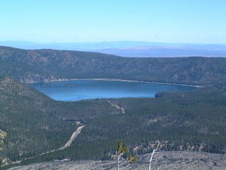
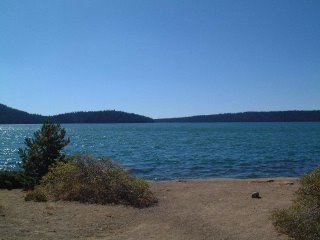
Everything I'd read about the Hart Mountain NAR said NOT to take an RV into the Refuge from the west (the western entrance climbs up Hart Mountain and is a gravel road). I had emailed the Refuge to find out what the "real" conditions were, and was told by the manager that it was about a 6% grade and the gravel should be in good condition in August. So we chanced it, stopping at the Hart Bar Interpretive Site at the northeast end of Hart Lake to unhook...we would drive the Lazy Daze and the Honda up the mountain separately. As it turned out, the road was no problem at all. It was in good condition, we were on the inside going up the mountain, and the grades weren't too steep.

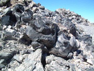
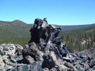
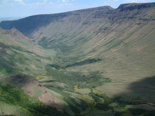
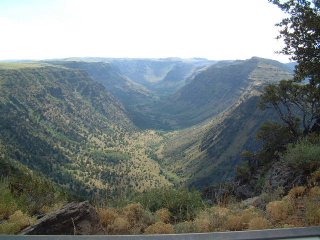
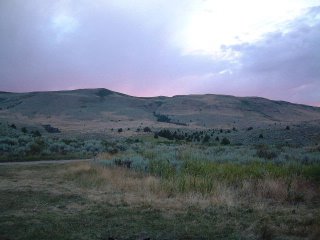
Hart Mountain is a massive fault block ridge (like Steens Mountain to the east) that rises to an elevation of 8,065 feet. The west side ascends abruptly 3,600 feet from the floor of Warner Valley. The east side of the mountain is less steep, descending in a series of hills and low ridges.
We arrived at Hot Springs Campground in the Refuge (free), and drove around to find a -- flat -- spot. These are really "unimproved" sites! We did finally find a fairly level spot in the portion of the campground across the road from the hot springs.

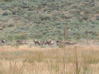
Although the name of this is Hart Mountain National Antelope Refuge, the "antelope" are really Pronghorn. While Pronghorn are related to true Antelope (both belong to the Order Artiodactyla) Pronhorn belong, all by themselves, to the Family Antilocapridae while the true Antelope belong to the Family Bovidae.

We found out that tomorrow is the start of bow-and-arrow hunting season for Pronghorn! Well, at least it's a quiet sport!

Thursday, August 04, 2005

Drews Creek Campground

After leaving Lava Beds National Monument, we stopped in Tulelake to dump tanks and do some grocery shopping.

We then drove SR-140 to Drews Creek Campground, a free BLM campground west of Lakeview, Oregon, and south of SR-140. This campground has potable water available as well as a couple of pit toilets. It's a nice quiet campground...except for the guy who zoomed by in his very loud car in the wee small hours of the morning -- and then came into the campground at sometime later.

Wednesday, August 03, 2005

Lava Beds National Monument


We left Medicine Lake and made the drive to Indian Well Campground in Lava Beds National Monument on about 17 miles of gravel road, some of it very rough.

We just happened to camp in the Camp Host's site which had full hookups (unoccupied, of course...and the hookups were locked, so campers couldn't use them). This looks like it might be a nice place to volunteer sometime in the future.

After setting up, we drove the Cave Loop Road, stopping to view some of the many lava tubes and caves in the area. Since we hadn't brought a flashlight with us, we didn't venture too far into the caves.

Lava Beds NM is located on the north flank of the Medicine Lake Volcano, a large shield volcano. Shield volcanoes have a very low profile due to the way they erupt. They tend to have gentle eruptions and lava that flows easily over large areas. (Composite or strato volcanoes are what many people think of when they hear the term "volcano." Mount Shasta in Northern California and Mount Rainier in Washington State are examples of composite or strato volcanos.) The Medicine Lake Volcano is the largest shield volcano in the Cascade Range, and is about 150 miles around the base and 7,900 feet high. The Monument covers only about 10% of the Medicine Lake Volcano.

Monday, August 01, 2005

Medicine Lake Campground, Modoc National Forest

We left Pit River Campground once the new camp host arrived and we'd had a chance to show her around (she'd actually shown up a week or two before to learn what was involved, so we just had some last minute items to share with her).

Our first stop was in Burney to fill up the propane tanks, gas up the Honda, and do some grocery shopping. Then it was on to Medicine Lake Campground in the Modoc National Forest, a trip of about 79 miles, where we spent a couple of days relaxing and cooling off. While at the campground, we put out our small stick-to-the-window hummingbird feeder, and had a female Calliope visit the feeder. Unfortunately, we never did see a male.

We took one of the short hikes offered in the area...a two-mile round trip to Little Medicine Lake. Later, Earl went back to fish in the lake, but didn't have any luck.