Wednesday, May 31, 2006


We took a trip part way down the Center Patrol Road to view birds. We got to see baby Coots, which were pretty cute! Coots are ugly birds, but the babies had orange bills, and orange-flecked fuzz on their heads.

We also saw a momma Ruddy duck with a whole passel of chicks!

Tuesday, May 30, 2006

We drove into Burns to do grocery shopping and have lunch. We were planning on having lunch at Linda's Thai Restaurant, which we've heard is very good. However, when we got there, a sign in the window said, "Gone to Bend for supplies." Rats! We ended up eating at The Apple Peddler.

Sunday, May 28, 2006

After the weekend of work...which was surprisingly light in the Visitor's Center, considering it was Memorial Day weekend (probably the weather was keeping the people away, since it was cold, cloudy, and rainy)...we decided to drive down to The Narrows for dinner. The Narrows is an RV park at the junction of SR-205 and Sodhouse Lane which goes to the Refuge Headquarters and also has a small restaurant with good food.

Wednesday, May 24, 2006

We drove into Burns today to do grocery shopping. We also stopped at the Big R to get Earl a long sleeve shirt, and picked up a stand from which we can hang our hummingbird feeder.

Tuesday, May 23, 2006


Tami Coe took Earl, David and Janet Free, and I on a tour down the Center Patrol Road, the main tour route in the Refuge. We stopped at Buena Vista Ponds Overlook (from which we had a good view of Steens Mountain), and stopped to have lunch at the hotel in Frenchglen.

Sunday, May 21, 2006

Our regular days for working here at the Refuge are Friday, Saturday, and Sunday. I'm working in the Visitor's Center and Earl is doing maintenance. Paul Larson (the Maintenance Supervisor, and Earl's immediate boss), had Earl mowing grass this weekend. Not too difficult a job since the mower is a big riding lawn mower!

We had a pretty busy weekend in the Visitor's Center with lots of birders coming in. There are lots of song birds as well as a few other birds that hang around the Visitor's Center, so we usually have a pretty good crowd on the Headquarter's grounds watching the birds. Some of these people are really serious birders with some serious equipment...binoculars, spotting scopes (both with and without cameras attached), etc. Some of these people must have several thousand dollars worth tied up in their equipment for watching birds!

The other couple who will be working in the Visitor's Center and doing maintenance during the week arrived on Friday (David & Janet Free).

Thursday, May 18, 2006

I spent yesterday and part of today at the Visitor's Center with Tami Coe (my immediate supervisor) in training. The "cash register" computer program is really easy to learn, so the job is mainly dealing with the public, answering questions, supplying people with brochures, and selling them gift shop items.

Tuesday, May 16, 2006

Earl and I walked down to the Visitor's Center to talk with Carey Goss (the Volunteer Coordinator), complete some forms and talk about our positions.

When we got back, Earl washed the car, and I cleaned the inside. Later in the day, we decided to drive a portion of the Center Patrol road (Carey is going to take us down the entire length next Tuesday) and on to Princeton. Of course, since these roads are gravel, the car was filthy on our return! Most of the dust was taken care of, though, with our California Duster (why is it called that?).

Monday, May 15, 2006

Malheur National Wildlife Refuge

We left Page Spring around 7:30 AM to have breakfast at the Frenchglen Hotel. Although we ordered blueberry pancakes, we got just plain pancakes...they were still good, but not like the blueberry! Next time, we'll make SURE the waitress has "blueberry" written down!

After breakfast, we drove into Burns to do grocery shopping, pick up some miscellaneous items at the Big R, and fill up both the Lazy Daze and the Honda with gas.

We then made our way to Malheur National Wildlife Refuge, stopping in the Visitor's Center first to let Carey Goss know we were here. We arrived just in time to have a slice of ice cream pie, a going away party for the volunteers we're replacing.

After eating, and checking in, we made our way to where we'll be parked for the next 2-1/2 months. We have full hookups, a concrete pad to park on, and a nice picnic table at our site.

Miles driven: 99.3
GPS coordinates: N43.2652 / W 118.83927

Sunday, May 14, 2006

Page Springs Campground

When we left Virgin Valley Campground, we back tracked on SR-140 to Denio Junction, and then continued north into Oregon on SR-205.

When we skirted Red Point (part of the Pueblo Mountains), we could see the eastern side of Steens Mountain...the first time we've seen it from the east. The higher elevations were covered in snow.

We stopped at the entrance to the South Loop Road to have lunch (we traveled the entire Loop Road through Steens Mountain last year...you can read about it at http://hometown.aol.com/linda0146/aug2005.html), and then continued on to Page Springs Campground, the first BLM campground on the North Loop Road. We have always stayed at Fish Lake Campground when we've visited Steens Mountain, but didn't want to travel the 18 miles on a gravel road this time. It's a good thing we had decided on staying at Page Springs Campground, though, because the North Loop Road is currently closed past this point.

This is a nice campground...many more trees than Fish Lake has, plus grass, but doesn't have the views of the higher campground.

Miles driven: 105.0
GPS coordinates: N42.8035 / W118.8671

Friday, May 12, 2006


We took a walk down the road past several ponds to view the wildlife. We spotted a Sandhill Crane and a Ruddy Duck (which has a blue beak during mating season), several Cinnamon Teals, as well as an assortment of other birds.

After lunch, we took a drive down to the Royal Peacock Mine just to see if we could find it. They do have an RV park at the mine with full hookups ($20 per day), and you can dig for your own opals ($110 per person per day if you dig at the main mine, or $40 per person per day if you dig at the tailings site).

Thursday, May 11, 2006

Virgin Valley Campground


We left Winnemucca around 10:00 AM, stopping for gas on the way out of town ($3.099/gallon).

We vacillated as to which way to go: US-95 all the way into Oregon, or cutting off on SR-140 and heading north. We decided on the latter route, and, although it was a bit out of our way, decided to go back to the Virgin Valley Campground in the Sheldon National Wildlife Refuge...a place we'd stayed last year. Stopping at a pullout to have lunch, we spotted a small herd of Pronghorn Antelope, and, later, a small herd of wild burros which are common on the Refuge. Unfortunately, we weren't able to stop to take pictures of the burros.

This is a nice, quiet campground...no services, but it's free. The Royal Peacock Opal Mine is down the road, but doesn't open until May 15, so we're too early again this year to go and dig for our own opals.

Miles driven: 124.6
GPS coordinates: N41.85245 / W119.00225

Wednesday, May 10, 2006

Winnemucca

We left Rye Patch SRA around 10:00 AM and drove to Winnemucca RV Park (in Winnemucca, Nevada...of course), stopping at the Raley's first to do some grocery shopping. Once we set up, we did laundry and then went out to dinner at the Model T Coffee Shop where they have an Early Bird Special for Seniors.

Miles driven: 51.7
GPS coordinates: N40.97992 / W117.7116

Sunday, May 07, 2006

Rye Patch SRA

On our way out of Churchill County Fairgrounds, we drained tanks, and filled up the fresh water tank. We also stopped at a gas station to top off the tank on the Lazy Daze ($3.27 / gallon).

We're spending the next couple of days at the campground in Rye Patch SRA south of Winnemucca, NV.

Miles driven: 82.5
GPS coordinates: N40.4668 / W118.30877

Saturday, May 06, 2006

We saw lots of llamas today!

The llama show is very similar to a dog show...each llama parades around the rink, and is judged by several people. There were a couple of pens set up that had llamas for sale, so we wandered over there so that we could get up close and personal with them. Only one llama...a yearling...came over to be petted. Their fur is sooooo soft! And they hum, too!

Friday, May 05, 2006

We were going to spend just one day at the fairgrounds, but they're having a llama show this weekend, so we decided to stay through at least Saturday so that we could see them.

Instead, we took the Honda into Reno to do some shopping, picking up our mail in Fernley on the way to Reno. On our way back, we stopped at Wendy's to have lunch.

Thursday, May 04, 2006

We left 20 Mile Beach late in the morning, and proceeded north on US-95 to Fallon. On our way into town, we stopped to fill up the propane tank in the Lazy Daze. Once that was completed, we headed to Churchill County Fairgrounds where we can dry camp for $5 per night (water and electrical hookups are $12...there is also a dump and fresh water on site).

After setting up, we drove into town to get groceries at Wal-Mart.

Miles driven: 51.0
GPS coordinates: N39.4584 / W118.7832

Wednesday, May 03, 2006

We left Miller's Rest Stop around 9:30 AM, stopping in Hawthorne for lunch. We though about going all the way into Fallon, another 70 miles, but quickly came to our senses, and proceeded to our original destination, 20 Mile Beach on Walker Lake.

20 Mile Beach is located on the northwestern shores of Walker Lake and has undesignated, dispersed camping (and, best of all, it's free!). At the moment, there is only one other rig at this beach...it should be a nice, quiet night!

Miles driven: 109.3
GPS coordinates: N38.748 / W118.7616

Tuesday, May 02, 2006

Having not been abducted by Aliens during the night, we continued our journey on the Extraterrestrial Highway this morning, to where it ends at US-6 at Warm Springs (or what used to be Warm Springs...there's nothing there now but a bunch of derelict buildings).

We stopped in Tonopah for gas ($3.199 per gallon) and groceries, and then made our way about 10 miles west of Tonopah on US-6 to Miller's Rest Stop. This rest stop has a section especially for RVs where you can stay for up to 18 hours...this is our third stay here. Miller's also has a dump station and fresh water, which we will avail ourselves of tomorrow morning when we leave.

Miles driven: 128.5
GPS coordinates: N38.14133 / W117.45637

Monday, May 01, 2006

Somewhere on the Extraterrestrial Highway!


We left Baker Reservoir Campground around 9:30 AM and headed north on SR-18 to Enterprise, Utah where we filled up with gas ($2.799 per gallon) and stopped at the grocery store to pick up a few supplies.

We then continued on into Nevada, deciding to head south on US-93 to the cutoff for the Extraterrestrial Highway (SR-375), so named because of it's location near the famous (or is that infamous?) "Area 51," a government base which officially doesn't exist, and where many believe the government conducts experiments involving captured UFOs.

We drove this highway last year (you can read about it at 
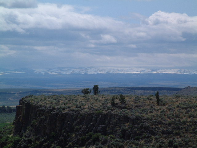
http://hometown.aol.com/linda0146/apr2005.html), staying at the Little A'Le'Inn in Rachel, the only town on SR-375. Since we'd been there, done that, this time we decided to stay somewhere else. About 10 miles east of Rachel is Coyote Summit (elevation 5,591 feet) where there is a large pull off on the south side of the road. It took some doing to find a somewhat level spot, but we finally succeeded. It was a nice quiet spot -- except for the jets from Nellis Air Force Range screaming overhead, breaking the sound barrier just about the time they got over us (which they did about three or four times)! Maxx doesn't like thunder, and a jet breaking the sound barrier sounds like the loudest clap of thunder you've ever heard!

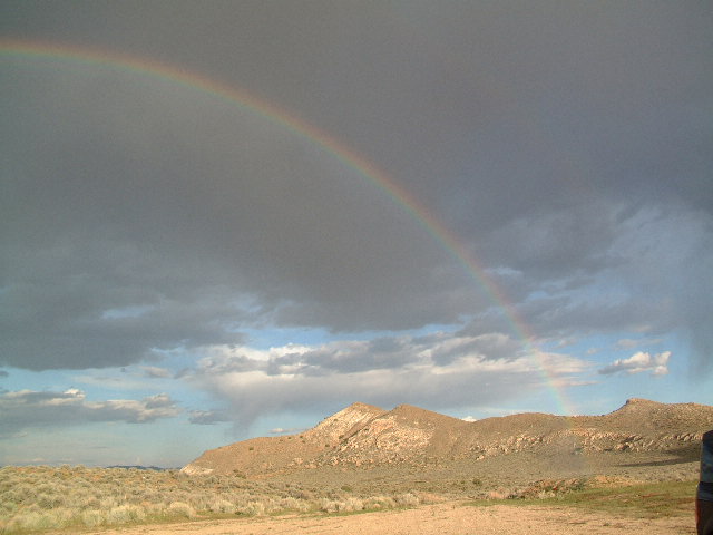
It rained a little bit, and we got to see a rainbow. It was actually a double rainbow, but the second one was very faint, and doesn't show up in the pictures.

Miles driven: 163.9
GPS coordinates: N37.57138 / W115.6688